

The Finnish Natural Resources Research Foundation co-financed Jiri Pyörälä’s dissertation, “Assessing wood properties in standing timber with laser scanning”.
Pyörälä graduated as a forester from the University of Helsinki (University of Helsinki) in 2014, and soon after began working on a dissertation topic at the Academy of Finland’s Center of Excellence in Laser Scanning Research (2014-2019). In the Center of Excellence, Pyörälä worked as a joint researcher at the University of Helsinki and the Finnish Geospatial Institute (FGI). Interdisciplinary research yielded novel perspectives on both forest and wood sciences and remote sensing. In Pyörälä’s dissertation, the theory of tree formation was combined for the first time with modern methods of remote sensing of forests.
In the picture above Dr. Pyörälä in the public examination of his doctoral dissertation which took place in Helsinki the 18th of September 2020.
_______________________________________________________________________
Laser scanning in the South Karelian woods.
The inventory of forest resources has a long tradition in Finland, and the national data reserves on forest area, stand volume and growth are uniquely comprehensive and accurate. The large-scale introduction of remote sensing, and in particular laser scanning, in forest inventories in this millennium has further improved the extent, accuracy and up-to-dateness of these data. As the technology continues to evolve, forest resource data will also become more diverse and detailed in the future. One major shortcoming in current forest resource data is the lack of information on quality of forests and stands, which has implications for the sustainability of forest resource use.
The sustainable use of forest resources involves the utilization of the wood raw material to be harvested as accurately as possible and in such a way that most of the carbon contained in the wood is stored in long-term wood products, mainly sawn timber. Thus, the planning of sustainable forest use requires information not only on the amount of wood, but also on the properties of the wood that affect those of the final product, such as the strength of sawn timber. Wood properties also affect forest carbon sinks and storage, the assessment of which is currently based almost exclusively on forest volume.
The reason for the lack of wood property data in the forest inventories is simple: adequate identifiers are beyond the reach of traditional measurement methods. Assessing wood properties in standing timber requires more detailed indicators of trunk geometry, branches, and canopy proportions than the “ordinary” stand identifiers (e.g., stand area, height, and diameter distribution). In wood formation, trees allocate their resources between length and girth increments, competing for e.g. light, water and nutrients. The results are reflected in the trunk shape and canopy structure of the trees. In addition to external factors, the allocation of growth is influenced by, for example, the water transport potential required by the length increase and, on the other hand, the mechanical strength required by the increasing mass. Thus, the anatomy of wood varies not only between trees, but also within them — both from pith to surface, and from base to top. One distinction can be made regarding the properties of wood between the so-called juvenile wood formed under the influence of the living canopy, and the mature wood formed below it. Thus, it can be deduced from the external features of the wood how the trees have allocated their growth and how the allocation has affected the properties of the wood formed (Figure 1).

Figure 1
Figure 1. The properties of wood are determined in wood formation, as the tree allocates the length and girth growth between different tree parts. From the external features of the stem and crown, the allocation of growth, and the properties of the wood formed can be deduced.
Three-dimensional point cloud data, collected by laser scanning both above and below the canopy, significantly eases detailed trunk and branch measurements from standing timber (Figure 2).

Figure 2
Figure 2. The laser scanning data collected from aerial and terrestrial view-points form three-dimensional point clouds of the objects, from which it is possible to measure e.g. stand height, canopy metrics, stem geometry, and the branching of the tree.
Laser scanning sensors and platforms are constantly evolving, as are the density, accuracy, and coverage of point clouds. Powerful laser scanners mounted on mobile platforms, such as drones or harvesters, both on the ground and in the air, can in the future produce accurate trunk and branching data from individual trees, even for real-time decision-making. Combining accurate forest data based on point clouds with data collected operationally in forest industry factories created the basis for large data reserves, on the basis of which it would be possible to map the properties of wood already when planning wood procurement (Figure 3). More carefully targeted, quality-based wood procurement planning would promote the sustainable use of forest resources and provide added value to the entire forest industry value chain.
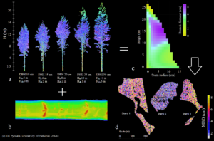
Figure 3
Figure 3. An example of remote sensing – based assessment of wood properties in future wood procurement planning:
a) Terrestrial laser scanning records accurate information on the stem and crown geometry of trees
b) Sawmills measure wood properties, e.g. by X-ray tomography
c) By combining laser scanning and X-ray data, tree-specific wood property models are developed
d) Wood property models are generalized to stands by aerial laser scattering
In addition to what was studied in Pyörälä’s dissertation, other novel and important applications for the mapping of forest resources using laser scanning are e.g. assessment of the health and diversity of forests, and the effects of different forest management options on their ecology, growth and yield. Multidisciplinary cooperation is crucial for harnessing the new technologies to support such planning and decision-making that promote both the diversified use of natural resources, as well as their protection as important carbon sinks and natural habitats.
Pyörälä, J. (2020). Assessing wood properties in standing timber with laser scanning. Dissertationes Forestales 295.